Geospatial Reasoning and Generative AI: Unlocking New Frontiers in AEC Decision-Making
Artificial Intelligence
4
min read
April 8, 2025

# Geospatial Reasoning and Generative AI: Unlocking New Frontiers in AEC Decision-Making
In the Architecture, Engineering, and Construction (AEC) industry, almost every project begins with a deceptively simple question: **Where?**
The process of answering that question—site selection, feasibility analysis, early-stage design—is anything but simple. It involves collecting, integrating, and interpreting vast and disparate geospatial datasets. From underground utilities and zoning overlays to traffic flows, topography, and climate data, the decisions made at this early stage influence cost, viability, risk, and long-term project performance.
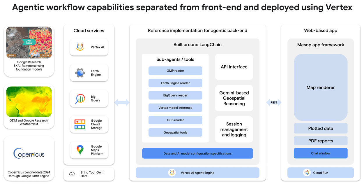
A new class of AI models—**geospatial reasoning systems powered by foundation models**—is poised to radically improve how this process is done. As outlined in a recent research post by Google DeepMind, the ability to reason over GIS data using natural language, vision models, and spatial embeddings offers unprecedented capabilities for decision-making in the built environment.
This article explores how geospatial generative AI can reshape key processes across the AEC lifecycle, with a focus on applied use cases, emerging capabilities, and the opportunity to embed these systems into automated, agent-driven workflows.
---
## Understanding Geospatial Reasoning with Generative AI
At its core, geospatial reasoning refers to the capacity of AI systems to interpret, interact with, and make inferences from spatial data—both above and below ground. Google’s system combines multiple foundation models across modalities (language, vision, spatial) to:
- Interpret complex map data
- Generate responses to natural language queries grounded in spatial understanding
- Perform reasoning tasks like spatial comparison, feature classification, or forecasting
- Integrate structured and unstructured sources such as satellite imagery, map layers, or textual descriptions
These capabilities are not limited to static analysis. When embedded into workflows, these models can simulate scenarios, suggest optimal decisions, and even generate visual or tabular outputs tailored to user needs.
For the AEC industry, where spatial decision-making is fundamental, the implications are transformative.
---
## From Context to Action: Why This Matters in AEC
AEC professionals operate in a context where spatial data is abundant but fragmented. GIS systems, satellite feeds, open data platforms, planning databases, and proprietary site scans often live in silos. Extracting insights from them is manual, time-consuming, and dependent on skilled specialists.
By enabling reasoning over multimodal geospatial data using natural language prompts or programmatic instructions, generative AI shifts the bottleneck. It no longer lies in accessing the data—but in asking the right questions.
And these questions can now be answered faster, earlier in the process, and with far greater contextual awareness.

---
## Practical Use Cases in AEC
Below, we explore concrete applications of geospatial reasoning AI in the AEC industry—each grounded in real-world decisions made daily by developers, engineers, planners, and builders.
---
### 1. Parcel and Site Prospecting
One of the earliest phases in development involves identifying parcels that meet a complex combination of criteria—location, zoning, access, demographics, utilities, and risk factors.
Geospatial AI systems can analyze entire regions in minutes to surface candidate parcels based on constraints like:
- Distance from transit corridors
- Inclusion in specific zoning codes
- Avoidance of floodplains or hazardous soil zones
- Proximity to labor pools, amenities, or urban centers
This reduces weeks of manual screening into seconds and supports transparent, auditable site selection workflows.
---
### 2. Feasibility Analysis and Buildable Area Estimation
Identifying a parcel is just the beginning. Determining whether it's **buildable** requires overlaying numerous datasets: easements, setbacks, slope, soil condition, underground utilities, right-of-way constraints, and more.
With generative AI, these constraints can be modeled spatially and interpreted collectively. The system can estimate total buildable area, propose optimal massing, and flag conflicts—e.g., a utility line intersecting a proposed foundation footprint.
For engineering teams, this creates a shared, data-informed starting point for design development.
---
### 3. Subsurface Conditions and Foundation Planning
Access to subsurface data—borehole logs, soil type maps, groundwater levels—is critical to foundation engineering. Yet this data is often unstructured or exists in scanned documents, reports, and siloed datasets.
Vision-language models can extract, structure, and reason over these datasets, combining them with surface-level GIS to generate foundation suitability maps or compare ground conditions across candidate sites.
When tied into structural design tools, this can inform decisions on slab types, piling requirements, or alternative geotechnical strategies early in the process.
---
### 4. Infrastructure and Logistics Modeling
Construction feasibility depends not just on the site, but on how resources and people get there.
By integrating routing data, road classifications, supply chain infrastructure, and traffic flow models, geospatial AI can simulate transport logistics—estimating travel times, carbon impact, or access constraints based on real-world networks.
This is especially valuable for large-scale industrial projects, remote developments, or modular/offsite construction strategies where delivery logistics are a major cost and risk factor.
---
### 5. Environmental and Climate Risk Assessment
With growing scrutiny around climate resilience, assessing risk exposure is no longer optional.
Generative models can combine historical weather data, floodplain maps, wildfire risk zones, and projected climate data to surface vulnerabilities or simulate long-term environmental stressors.
For example, developers planning solar arrays can optimize panel orientation and layout based on solar irradiance, prevailing winds, and shading patterns—factoring in long-term climate forecasts, not just current conditions.
---
### 6. Urban Context and Demographic Intelligence
Understanding the human context around a site is vital for mixed-use, residential, and commercial developments.
Geospatial reasoning models can map population density, age distributions, income brackets, commuting patterns, and proximity to schools, healthcare, and retail—all spatially resolved and dynamically queried.
Urban planners and developers can use this to align program mix, phasing, or marketing strategy to the demographics of the catchment area.
---
### 7. Permitting and Regulatory Analysis
Planning decisions are constrained by local codes, overlays, and regulatory boundaries.
Foundation models can ingest local zoning codes, planning overlays, and permit histories—linking spatial data to legal and procedural requirements. When paired with site selection, the AI can flag compliance risks, required variances, or entitlement strategies based on local precedent.
This accelerates due diligence and creates a bridge between planning consultants, legal teams, and project managers.
---
### 8. Scenario Simulation and Policy Impact Modeling
Beyond single-site analysis, geospatial AI can model broader urban scenarios.
Planners can simulate how rezoning a corridor affects transit ridership or how shifting development inland changes stormwater runoff. Developers can assess how densification affects neighborhood amenities or parking demand.
These models can generate not just numbers, but narratives—maps, visualizations, and executive summaries that support stakeholder communication and public consultation.
---
### 9. Disaster Response and Post-Event Analysis
Post-disaster assessment is often hampered by lack of up-to-date spatial information.
Generative models can fuse satellite imagery, sensor feeds, and government data to generate near-real-time impact assessments—identifying damaged structures, impassable roads, or utility disruptions.
This can inform emergency repair workflows, insurance claims processing, and risk modeling for future resilience planning.
---
### 10. Digital Twin Integration and Model Enrichment
Digital twins are only as good as the data they contain.
Geospatial AI can serve as a continuous input layer, enriching BIM and GIS twins with updated spatial intelligence—from aerial scans to demographic shifts.
Moreover, foundation models can act as intermediaries, answering natural language questions from non-technical stakeholders using the twin as a knowledge base.
---
## Embedding Geospatial AI into AEC Workflows
What makes these capabilities transformative is not just the insight they generate—but how they integrate into workflows.
When paired with agentic AI systems—autonomous agents that can plan and execute tasks across software interfaces—geospatial reasoning becomes part of an end-to-end toolchain. Agents can:
- Query parcel databases
- Pull zoning overlays
- Simulate layouts
- Generate reports
- Push results into design tools or collaboration platforms
The result is not a standalone AI model, but an intelligent assistant embedded in your site selection, planning, and design processes—operating at speed and scale, 24/7.
---
## Implementation Considerations
Deploying these systems in practice requires careful attention to:
- **Data availability**: Integrating proprietary and public datasets into a consistent spatial framework
- **Model grounding**: Ensuring that generative responses are anchored in real, verifiable data
- **Governance**: Managing data provenance, regulatory compliance, and auditability
- **Tooling integration**: Connecting AI outputs with existing GIS, BIM, and project management tools
AEC organizations that start investing in this capability today will not only reduce manual effort—they will unlock new levels of insight and agility in how they evaluate, plan, and deliver the built environment.
---
## Closing Thoughts
Geospatial reasoning with generative AI is not a research curiosity—it’s a working capability that is already beginning to reshape decision-making in real estate, infrastructure, and urban development.
For AEC leaders, the opportunity lies in combining these models with domain expertise and operational workflows. The goal is not to replace planners or engineers—but to give them superpowers.
The firms that succeed in this transformation will be those that understand one simple truth:
**Better spatial intelligence leads to better built outcomes.**